

I'm Stefano, and I guide people through the Tuscany most tourists never see. Want to hike in Tuscany with me?
Last updated 8 October 2026
The mountains near Pisa begin ten minutes up the railway. Monte Pisano, the wooded ridge you see east of the city, has a station at its foot in San Giuliano Terme, and the paths start almost as soon as you leave the platform. The Apuan Alps are the pale wall on the northern skyline, and the trailhead I use there is 61 km from Pisa by road. The Apennines rise further inland, out of sight from the tower.
Each of the three ranges makes a different day trek from Pisa. I’ve put the hiking trails near Pisa below in order of effort, from a level morning beside an aqueduct to a full day on the Apennine crest, with how you get to each one and whether I guide it. One of them I don’t, and I’ll say which.
More than a quick stop in Pisa? A local’s Expert Brief turns it into a base for real day treks. Already in Tuscany? Send me your dates on WhatsApp and I'll tell you what we can do together, and when.
The Mountains Near Pisa at a Glance
| Walk | Range | From Pisa | Distance and climb | Time |
|---|---|---|---|---|
| Nottolini aqueduct | the plain below Monte Pisano | train to Lucca, 25–30 min | 9.1 km, 50 m, flat | about 3 h |
| Passo di Dante, on your own | Monte Pisano | train to San Giuliano Terme, about 10 min | a steady climb, never technical | 2–3 h there and back |
| Marmifera del Corchia | Apuan Alps | car, 61 km | 7 km, 420 m | about 3.5 h, weekends only |
| Monte Gennaio · Lago Nero · Lago Scaffaiolo | Apennines | car, 75–85 km | 8–9.5 km, 370–500 m | 5–6 h |
You can reach the first two without a car. For the last two there’s no practical public transport to the trailheads, so if you don’t have a car, tell me when you write and I’ll help you find a solution.
Monte Pisano: The Ridge Behind the City
Monte Pisano runs between the Pisa plain and the Lucca plain, and it stays under 1,000 metres. Monte Serra, the top, measures 917. Olive terraces climb its lower slopes and chestnut woods take over above them. For centuries the ridge was the border between Pisa and Lucca, and the one walk I’ve guided on it climbs to a fortress built to hold that border. The paths carry the CAI’s red and white waymarks, with the path number painted in the white band.
You can walk here all year. Spring brings the wildflowers and the fresh green of the laurel, and autumn has the best light. In summer the olive slopes near the bottom give you no shade at all, so I’d start early and save the woods for midday. After a long spell of rain the limestone turns slick, and you’ll feel it on the way down.
Passo di Dante, by train from San Giuliano Terme
I don’t guide this one, and you won’t need me for it. San Giuliano Terme, a small spa town at the edge of the plain, has its own station on the Pisa–Lucca line, about ten minutes from Pisa Centrale. Follow the signs toward the hills from the station and the path network begins almost at once, with olive groves and low stone terraces first and woodland as you gain height.
The climb is steady and never technical. I’d wear proper shoes for the steeper stretches and allow two to three hours there and back. The pass itself is a narrow gap in the crest. On one side the plain runs out to Pisa and the sea, on the other the woods drop toward the Serchio valley, and on a clear day the tower shows as a white stroke in the middle of the city.
Dante names this ridge in Inferno XXXIII as the mountain that keeps the Pisans from seeing Lucca, though whether he ever crossed here, nobody knows. From the pass you can come back the way you went up, carry on along the ridge, or drop down the Lucca side and make your own way back to the railway. I’d look up the return trains before setting off, because they thin out in the evening. The route notes are in the car-free guide.
Ripafratta, closed for now
The ridge’s other station is Ripafratta, and that’s where I used to take people up to the Rocca di San Paolino, a fortress that took its shape in the 12th century on the old border. Restoration works have closed the castle and blocked the path a short way below the walls. The sign at the works gives no end date and I don’t know when it will reopen, so I’ve taken that day off sale. The walk I guide in its place leaves from the same railway, and it’s the flattest one on this page.
The Nottolini aqueduct, the flat day I guide
This one starts in Lucca, a short walk from the station, and the regional train from Pisa takes 25 to 30 minutes. From there about 460 arches run across the plain toward the foothills of Monte Pisano, built between 1823 and 1851 to carry spring water into the city. You walk beside them on level ground: 9.1 km and 50 metres of climb, about three hours. If you’d rather drive, the start is 19.7 km from Pisa.
When I guide it we carry on past the last arch to the source that feeds it, then come back the same way. Tired legs, small children and cameras all do well here.
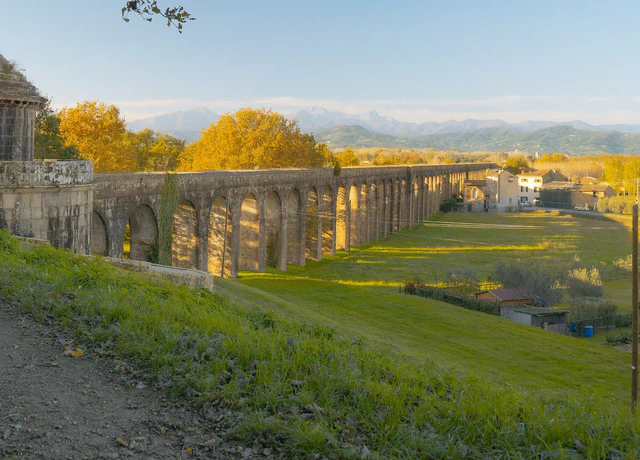
Nottolini Aqueduct
The aqueduct doubles as a sundial. Once a day the light runs straight down its corridor of arches, at a time that shifts through the year.
- About 3 hours
- €165 per group
- Reachable by train
- Longer route to a view over Lucca, on request
Easy · 9.1 km (5.7 mi) · 50 m (164 ft) ascent
View this hikeTo walk it alone, follow the photography guide to the aqueduct, which takes you through the route stretch by stretch.
The Apuan Alps: Marble, 61 km North
Drive north and the hills stop being hills. The pale flanks you saw from Pisa are marble, quarried in the Apuan Alps since Roman times, and the range tops out at 1,946 metres on Monte Pisanino.
I guide the Marmifera del Corchia, an unpaved road cut into the mountainside to bring marble down from the Corchia quarries. The trailhead at Passo Croce, above Levigliani, is 61 km from Pisa, and you’ll need a car, because no station has a practical connection to it. I only walk it on Saturdays and Sundays, since the marble trucks use the road all week.
On paper it’s 7 km and 420 metres of climb, about three and a half hours, and I rate it medium-easy because nothing on it is technical. The effort is real, though. Every one of those 420 metres sits in the first half, one long pull with nothing flat to recover on, and the way back is the same road downhill. The quarries are working private sites, so we walk past them, not into them. Marble dust coats the roadside leaves the whole way up, and that’s what I point out as we walk. We stop when the light is worth it.
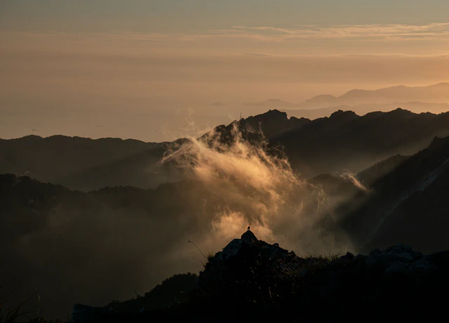
Marmifera del Corchia
The road climbs past active quarries with Viareggio and Forte dei Marmi below you. On clear days you can pick out Corsica.
- About 3.5 hours
- €210 per group
- Saturdays and Sundays only
Medium-Easy · 7 km (4.3 mi) · 420 m (1,378 ft) ascent
View this hikeThe full story of the road, and how to plan around its weekends, is in my marble quarry hike post.
The Apennines: High Lakes and a Summit
The third range doesn’t show from Pisa at all. The Tuscan-Emilian Apennines run along the border with Emilia-Romagna, and the three routes I guide up there start between 1,300 and 1,500 metres, 75 to 85 km from Pisa by road. Each one takes the whole day.
Monte Gennaio, 75 km away, is the summit day. You climb 500 metres over 9.5 km, through old beech forest and onto the border ridge at 1,814 metres, and the last stretch to the top is steep. Give it about six hours, and I’d keep it for walkers already used to a long climb. Lago Nero, 80 km out, sits in a glacial basin at 1,730 metres, and I take the same path there and back, 8 km with 450 metres of climb, about five hours with stops. Lago Scaffaiolo, at 85 km the furthest, lies right on the crest at 1,775 metres, with 9.5 km and 370 metres of climb in about six hours. Rifugio Duca degli Abruzzi stands beside it. It opens every day from mid-June to mid-September and at weekends for the rest of the year except November, so check its dates before you count on a meal there.
The season up here is shorter than on Monte Pisano. After a heavy winter, snow can still lie on the crest in May, and by November the ridge can carry ice while the plain is still mild. July and August are when these heights earn their drive, because everything below 1,000 metres is hot.

Lago Scaffaiolo
Once you’re up, the path runs along a broad, grassy crest to the lake, with Tuscany on one side and Emilia-Romagna on the other.
- About 6 hours
- €240 per group
- Shorter or longer day on request
Medium · 9.5 km (5.9 mi) · 370 m (1,214 ft) ascent
View this hikeMonth by month, my lakes post sets out when the two lakes are actually walkable.
How to Choose Your Trek
- No car? The Nottolini aqueduct with me, or the Passo di Dante on your own. Both start from a platform.
- Only a morning? The Passo di Dante, ten minutes on the train and two to three hours on foot.
- Children along? The aqueduct. It stays level the whole way and you can turn back at any arch.
- A Saturday with a car? The Marmifera del Corchia, the one walk here I can only guide at weekends.
- A whole day and good legs? The Apennines, with a lake or a summit at the end of the climb.
No car in Tuscany? Plenty of my hikes work perfectly without one. Browse the train-accessible hikes.
On Your Own or With Me
The trains run and the paths are waymarked, so the Passo di Dante needs no guide, and with the photography guide in hand neither does the aqueduct. What I add on the days I guide is the ground itself: the plants and fungi we pass, where to stand when the light is right, and a route built around your train times or your weekend. Every walk I guide from the city is on my hiking near Pisa page, with distances and difficulty for each.
Still deciding how long to stay? I’ve answered is Pisa worth visiting separately. If you’re thinking about hiring a guide, here’s what to look for.
Plan a Day Trek from Pisa
Looking for a guided day in the Apuan Alps, the Pistoiese Apennines, or along the Nottolini Aqueduct? Book a consultation to find the right experience for your time in Pisa.