

I'm Stefano, and I guide people through the Tuscany most tourists never see. Want to hike in Tuscany with me?
Last updated 4 November 2026
The advice you’ll find everywhere about exploring Tuscany on foot is almost always the same: rent a car.
For most of the region, that advice is accurate. But for the stretch of landscape between Lucca and Pisa, it’s wrong.
A single railway line, the Trenitalia regional service connecting Pisa, Lucca, and the Garfagnana, threads directly through one of the most hikeable corners of Tuscany. The towns it stops at aren’t just convenient transit points. Several of them are trailheads.
This guide covers the best hiking options you can reach from Lucca or Pisa Centrale without a car, from an easy morning walk starting directly behind the station to a medieval fortress in the hills above the Serchio valley.
Doing Tuscany without a car? A local’s Expert Brief shows you what you can reach by train. Already in Tuscany? Send me your dates on WhatsApp and I'll tell you what we can do together, and when.
The Railway as a Trail System
The Pisa–Lucca–Aulla regional line is worth understanding before you plan anything, because it changes the geometry of hiking in this area.
From Pisa Centrale, trains reach Lucca in approximately 30 minutes. From Lucca, the line continues north through the Serchio valley, stopping at villages along the western face of Monte Pisano before climbing into the Garfagnana.
This means you can:
- Start a hike in Lucca and return from Pisa (or vice versa), using both cities as endpoints
- Get on at a midpoint station and hike into either city
- Take the train to a trailhead village, hike a loop, and return on the same line
The tickets are inexpensive. The trains run roughly hourly. And the landscape along the line (Monte Pisano rising between the two plains, the Serchio river, chestnut forests and olive terraces) is exactly the kind of terrain that rewards walking.
No car in Tuscany? Plenty of my hikes work perfectly without one. Browse the train-accessible hikes.
Starting From Zero: The Nottolini Aqueduct Walk
If you arrive at Lucca train station with no plan and want to be walking in beautiful countryside within ten minutes, this is your trail.
The Nottolini Aqueduct starts barely a five-minute walk from Lucca train station. Take the underpass to the south side of the tracks, turn left on Via Nottolini, and after a short stretch you’ll find the Tempietto di San Concordio, a neoclassical cistern that marks the aqueduct’s end point in the city.
From here, the itinerary is mainly flat and runs along the arches and temples of the aqueduct for about 4 km, until reaching the beautiful meadow called “Parole d’Oro”, a suggestive place with springs.
The aqueduct itself is the spectacle. In 1822, the Duchess of Lucca commissioned architect Nottolini to build a structure that could bring water from the springs in the Monte Pisano foothills into the city. It took 10 years to construct the 460 arches of the three-kilometre aqueduct. The result, a long, perfectly straight line of neoclassical arches disappearing toward the hills, is one of the more visually striking things you can walk alongside in Tuscany, and almost no one outside the local area knows it exists.
From Parole d’Oro, hikers with more energy can continue uphill on the CAI 128 trail toward Vorno, entering proper Monte Pisano forest terrain. This adds both elevation and options: from Vorno you can loop back or push further toward the ridge.
Make sure you have appropriate footwear for the unpaved sections. The same hiking boots you’d use for any trail hike serve well here.
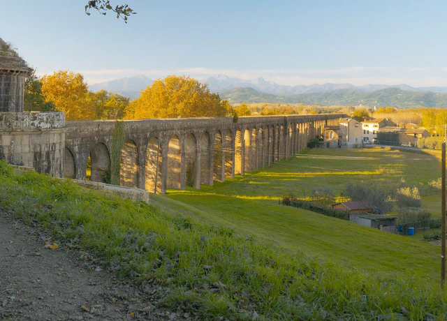
Nottolini Aqueduct
The aqueduct doubles as a sundial. Once a day the light runs straight down its corridor of arches, at a time that shifts through the year.
- About 3 hours
- €165 per group
- Reachable by train
- Longer route to a view over Lucca, on request
Easy · 9.1 km (5.7 mi) · 50 m (164 ft) ascent
View this hikeThe Centrepiece: Rocca di Ripafratta by Train
Closed for now. Restoration works have closed the castle, the path is blocked a short way below the walls, and the sign at the works gives no end date. I’ve paused this walk until it reopens. Until then, the Nottolini aqueduct above is the car-free half day I guide.
Here is the hike I’d send anyone to who wants to combine genuine history, beautiful terrain, and a guided experience, and who is arriving by rail.
Ripafratta has its own station on the Pisa–Lucca line. Trains run regularly from both cities throughout the day, and the station is a short walk from the village and the starting point of the hike. From Lucca the journey takes about 10 minutes. From Pisa Centrale, about 20.
The destination is the Rocca di Ripafratta (also known as Castello di San Paolino), a medieval fortress built to control the strategic passage between the Pisan and Lucchese plains. It stands on Monte Pisano above the Serchio valley, with views that stretch across both cities’ plains on a clear day.
What makes this hike distinctive:
The trail climbs through hillside terrain dense with Bay Laurel, Laurus nobilis, one of the most characterful plants in the Tuscan Mediterranean flora. The fragrance as you move through it in the morning is something that stays with you. Monte Pisano is covered with protected biodiverse areas and is full of hiking trails, its landscapes unmistakable, where humankind has worked in harmony with nature.
At the fortress itself, the history is layered in ways that reward explanation. The castle took its shape in the 12th century, built to hold one of the most contested borders in medieval Tuscany. In 1504 the Florentines rebuilt it for the age of cannon, and by 1607 it stood abandoned: two distinct historical chapters visible in the same stones.
Once it reopens, most of the day goes on the walls at the top, which sit directly above the point where the Serchio squeezes through the rock. Catch a morning train and you’re back down in time for lunch in either city.
A Ridge Crossing: Passo di Dante from San Giuliano Terme

Passo di Dante is one of the more atmospheric routes on Monte Pisano, a narrow crossing through the ridge that feels far more remote than it actually is.
San Giuliano Terme has its own station on the Pisa–Lucca line. From Pisa Centrale the journey takes around 10 minutes. From Lucca, about 20. From the station, follow signs toward the hills and the trail network begins almost immediately: olive groves, low stone terraces, then proper Mediterranean woodland.
The ascent is steady but never technical. As you gain elevation the terrain shifts, olive trees give way to mixed forest, and the views open behind you toward the Pisa plain.
The pass itself is a narrow passage through the ridge, traditionally associated, more by legend than certainty, with Dante Alighieri during his travels in exile. Whether or not he crossed here, the name fits the mood. On one side, the flat expanse stretching toward Pisa and the sea. On the other, the quieter interior of Monte Pisano, forested slopes falling toward the Serchio valley.
From the pass you can return the way you came, continue along the ridge for a longer loop, or descend toward villages on the Lucca side and link back to the railway.
What makes this hike stand out is the contrast. You start in a spa town at the edge of the plain and within an hour you’re in a narrow mountain passage with views in both directions. Allow 2–3 hours for a return, good footwear recommended on the steeper sections.
Practical Notes for Train-Based Hiking
A few things worth knowing before you plan:
Timetables: Check current schedules on Trenitalia before your visit. Regional trains run roughly hourly but gaps exist, particularly in the evening. Plan your return train before you start walking.
Tickets: Buy at the station or via the Trenitalia app. Validate before boarding, at the machines on the platform, not on the train.
Seasons: The Monte Pisano trails are walkable year-round. Spring (March–May) brings wildflowers and green laurel. Autumn offers the best light and mild temperatures. Summer is warm but the forest shade keeps the trails comfortable at elevation.
The Lucca–Pisa corridor is one of the few places in Tuscany where arriving by train doesn’t limit what you can explore. In several ways, it enhances it.
If you also have a car for part of your stay, see my full guide to day trips from Lucca. It covers the drive-to options (the Apuan Alps, Acquerino, Lago Scaffaiolo) alongside these car-free routes.
For the guided versions, the full route lists sit on my hiking near Lucca and hiking near Pisa pages. While Ripafratta is closed, only the aqueduct starts at a station. For the others, tell me you’re travelling by train when you write, and I’ll help you find a solution.
The Aqueduct, Straight From the Station
The aqueduct walk starts ten minutes on foot from Lucca station and stays level almost the whole way, so it works with children too. Ripafratta is paused while its castle is restored. Send me your dates and how many of you are coming, and I’ll plan the day around your trains.