

I'm Stefano, and I guide people through the Tuscany most tourists never see. Want to hike in Tuscany with me?
Last updated 3 November 2026
Lucca is an easy city to stay in longer than planned.
The walls, the towers, the narrow streets, the restaurants. It holds people comfortably. And most visitors, after a day or two inside those medieval ramparts, are ready to go somewhere entirely different.
The good news is that Lucca sits at an unusual convergence of landscapes.
The Apuan Alps are to the north. The Pistoiese Apennines are to the east. Monte Pisano rises immediately outside the city walls. The Lucca plain extends southward, crossed by one of the most architecturally extraordinary walking routes in Tuscany.
Whichever direction you pick, the options are genuinely varied, from high glacial lakes to marble mountain roads to flat neoclassical aqueducts.
Here is how I think about day trips from Lucca, depending on how much time, fitness, and transport you have.
Here is every destination in this guide at a glance.
| Destination | From Lucca | Car or Train | Difficulty | Half / Full day |
|---|---|---|---|---|
| Nottolini aqueduct | On foot, from the walls | Neither | Flat, 9.1 km | Half day |
| Ripafratta (Rocca di San Paolino), closed for restoration | About 10 min | Train | Easy, 3.3 km, 130 m | Half day |
| Apuan Alps (Marmifera del Corchia) | 61 km | Car | Medium-easy, 7 km, 420 m | Half day |
| Riserva Acquerino | 64 km | Car | Medium-easy, 10.9 km, 375 m | Half or full day |
| Acquerino-Cantagallo | 63 km | Car | Medium, 9.5 km, 350 m | Half or full day |
| Lago Scaffaiolo | 67 km | Car | Full mountain day, 1,775 m | Full day |
| Padule di Fucecchio | Valdinievole plain | Car | Flat wetland | Half or full day |
The Corchia walk runs weekends only, when the marble trucks are not operating.
Settling into Lucca for a while? A local’s Expert Brief points you to the day trips worth taking. Already in Tuscany? Send me your dates on WhatsApp and I'll tell you what we can do together, and when.
The Classic Day Trips from Lucca (and What Most Visitors Miss)
Search “day trips from Lucca” and the same names come back: Pisa and its tower, Florence, the Cinque Terre, the hill town of Barga, Collodi and its Pinocchio park. They are famous for good reason, and every guidebook already covers them. This guide is about the other Lucca: the marble mountains, glacial lakes, ancient forests, and wetlands in this part of Tuscany that almost no one thinks to look for. If you have already seen the towns, or simply want a day outdoors instead of another museum queue, everything below is what most visitors miss.
Mountains Near Lucca
Three distinct ranges sit within easy reach of the city, and each reads completely differently.
The Apuan Alps rise to the north, 61 km away at the Corchia trailhead. These are the marble mountains: pale rock, exposed ridges, active quarries. They are the most dramatic terrain in the area, and unlike anything else in Italy.
The Pistoiese Apennines lie to the east, between 63 and 67 km out by road. Here the character softens into deep forest, open ridges, and high glacial lakes. The mood is quieter, the isolation greater.
Closest of all is Monte Pisano, rising immediately outside the walls. It is lower and gentler, a wooded ridge between Lucca and Pisa, reachable without a car. Ripafratta sits at its northern foot.
Day Trips from Lucca by Train (No Car Needed)
Not every rewarding day trip from Lucca needs a car. Several of the best are reachable on foot or by regional train, straight from the station: the coast and its wetlands to the west, a medieval fortress and the wooded slopes of Monte Pisano to the south, and a neoclassical aqueduct that starts within walking distance of the platforms. No rental required.
No car in Tuscany? Plenty of my hikes work perfectly without one. Browse the train-accessible hikes.
Acquedotto Nottolini: On Foot from Lucca Station
This one begins at Lucca itself and requires nothing more than walking shoes. The southern end of the aqueduct sits a short walk from the station, so even arriving by train you can be alongside the arches within minutes of stepping off the platform.
In the 1820s, the engineer Lorenzo Nottolini designed an aqueduct to carry spring water from the hills above Guamo into the city. What he built was not merely functional. It is a procession of neoclassical arches, nearly three kilometres long, that crosses the Lucca plain in a straight, confident line into open countryside.
Walking alongside it is one of those experiences that is difficult to explain before you have done it. The scale becomes clear only on foot: each arch is well above head height, the geometry repeats into the distance, and the landscape it crosses gradually shifts from urban edge to farmland to olive groves.
The full route is 9.1 km with virtually no elevation gain. Entirely flat, entirely walkable, entirely unlike anything else in the region.
It is also, from a photographic standpoint, one of the most composed and distinctive subjects in Tuscany. The light on the stone in morning or late afternoon does something that is worth planning around.
The walk doesn’t end where the arches do. We carry on to the source that feeds it, the quiet end of the walk, and come back the same way.
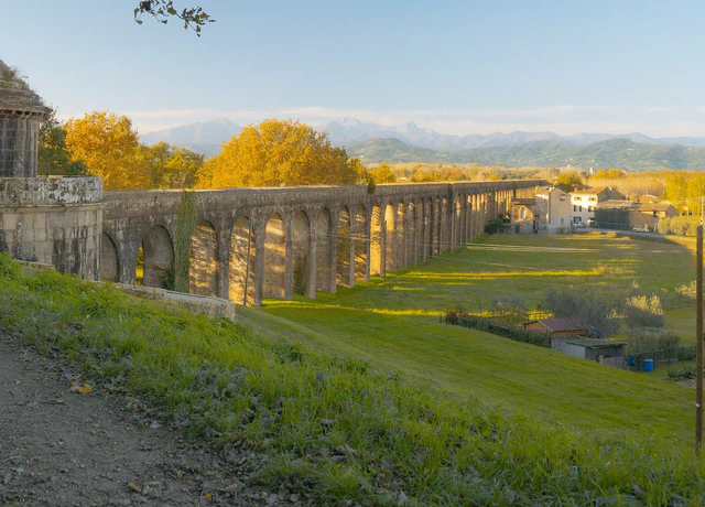
Nottolini Aqueduct
The aqueduct doubles as a sundial. Once a day the light runs straight down its corridor of arches, at a time that shifts through the year.
- About 3 hours
- €165 per group
- Reachable by train
- Longer route to a view over Lucca, on request
Easy · 9.1 km (5.7 mi) · 50 m (164 ft) ascent
View this hikeFull photography and walking guide to the Acquedotto Nottolini is here.
Ripafratta: About 10 Minutes by Train
The regional train from Lucca toward Pisa reaches Ripafratta in about ten minutes.
From the station, a short walk brings you to the base of Monte Pisano, where the Rocca di San Paolino occupies a commanding position on the hillside above the Serchio valley.
This fortress is one of the more significant pieces of medieval military architecture in western Tuscany, strategically placed to control the river passage between Pisa and Lucca, two cities that spent considerable effort trying to dominate each other across several centuries. The ruins make the logic of the position immediately clear.
The hike is short and accessible: 3.3 km, 130 metres of elevation gain, rated easy. The surrounding slopes carry a dense wood of bay laurel (Laurus nobilis), with an enclosed, ancient quality quite different from the open Apennine terrain further north.
Right now you can’t get up to it. Restoration works have closed the castle, the path is blocked a short way below the walls, and the sign at the works gives no end date. I’ve paused this walk until it reopens. For a car-free half day from Lucca in the meantime, take the Nottolini aqueduct above.
More on car-free hiking options near Lucca and Pisa is here.
Viareggio and Lake Massaciuccoli: The Coast by Train
The same regional network runs the other way, to the Versilia coast. Viareggio is around twenty-five minutes from Lucca by train, and it is more than a beach town: the Apuan Alps rise directly behind it, and just to the south lies Lake Massaciuccoli, the largest lake in Tuscany.
In summer the shallows fill with flowering lotus, and the reed beds are one of the richest bird habitats on the coast. It makes an easy half or full day, trading marble ridges for open water and sea light.
Day treks and nature around Viareggio are covered here. The summer lotus bloom at Lake Massaciuccoli is worth timing a visit around.
Pisa: Nature on the Direct Line
Pisa is about half an hour from Lucca on the same line, and most visitors only ever see the tower. Behind the monuments, Pisa is a working base for the wooded ridges of Monte Pisano, medieval castles, and marble country, all reachable without a car. From Lucca it is the easiest complete change of scene on the network.
The mountains near Pisa, and Pisa as a base, are covered here.
With a Car: The Apuan Alps
If you have a car and want a day that stays with you, head north into the Apuan Alps. The Corchia walk starts 61 km from Lucca.
These are not ordinary mountains. The Apuan Alps are marble mountains, the same stone that Michelangelo chose for the David, the same material that has been extracted from these hillsides since Roman times. The Pantheon in Rome, the cathedral in Pisa, much of the world’s architectural stone: it came from here.
The visual character of the range reflects this completely. White and grey veins cut through green forested slopes. The peaks above the treeline are pale where the rock is exposed. In certain afternoon light, sections of the mountain face appear to glow.
The quarries are still active, vast industrial operations that have reshaped significant sections of the range over centuries and continue doing so today.
Marmifera del Corchia
The hike I guide most frequently in the Apuan Alps follows the Marmifera del Corchia, an unpaved mountain road built specifically to transport marble from the Corchia quarries.
On weekdays, marble trucks use this road. On weekends, it becomes one of the most dramatically situated walks in the Apuan Alps, passing alongside active quarries, opening onto views across neighbouring peaks, and offering clear sightlines to the coast on good days.
The route is 7 km with 420 metres of elevation gain, rated medium-easy. The distance is modest, but the scale of what surrounds you is not.
Walking here makes the industrial and geological history of the range simultaneously visible in a way that looking at a finished cathedral floor never quite achieves. The quarries are not distant. You pass alongside them, and the scale of extraction over two thousand years of continuous operation becomes comprehensible in a way it cannot from below.
Important: this hike runs weekends only, when the trucks are not operating. A car is required to reach the trailhead.
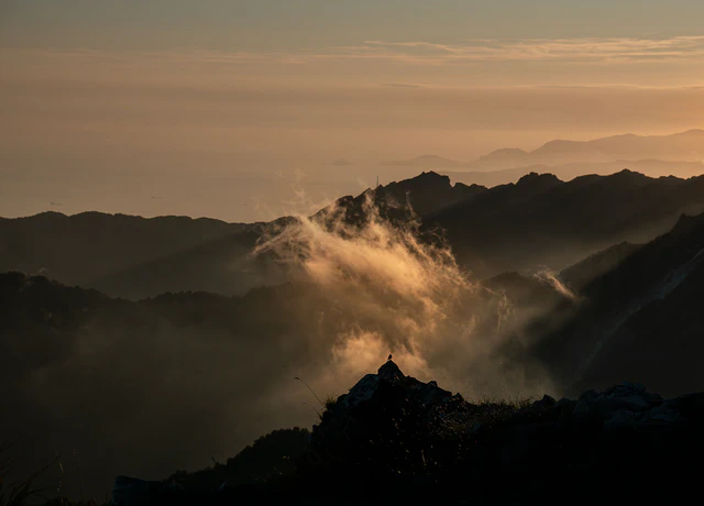
Marmifera del Corchia
The road climbs past active quarries with Viareggio and Forte dei Marmi below you. On clear days you can pick out Corsica.
- About 3.5 hours
- €210 per group
- Saturdays and Sundays only
Medium-Easy · 7 km (4.3 mi) · 420 m (1,378 ft) ascent
View this hikeFull details on the Apuan Alps marble hike are here.
With a Car: The Pistoiese Apennines
East of Lucca, with trailheads 63 to 67 km from the city depending on your destination, the Pistoiese Apennines offer a completely different landscape again.
Where the Apuan Alps are dramatic and geological, the Pistoiese Apennines are quieter: deep forests, open ridges, glacial lakes, and a quality of isolation that surprises visitors who expect the crowded Tuscany of postcards.
On an overcast morning in late summer or early autumn, the high Pistoiese ridge has a character that genuinely resembles the Scottish Highlands. Open moorland, low cloud, dark water. This is Tuscany on a completely different register, and almost no tourist infrastructure points toward it.
Acquerino: Ancient Forest, 23 to 24 km from Pistoia
The Acquerino nature reserve is the most accessible entry point into the Apennine forest landscape.
Two connected protected reserves, the Riserva Biogenetica di Acquerino and the Riserva Acquerino-Cantagallo, occupy the same continuous woodland, divided only by a bureaucratic boundary between the provinces of Pistoia and Prato.
The forest itself doesn’t acknowledge the distinction.
Mixed broadleaf woodland at lower elevations transitions into mature beech groves that close completely overhead at altitude. Meadow clearings break the canopy at intervals. In autumn, the combination of bracken, turning beech, and low Apennine light produces a landscape that photographers return to repeatedly.
Hunting is restricted, development is absent, and the ecological management shows: deer are common, woodpeckers audible long before they are visible, the undergrowth genuinely undisturbed.

Acquerino-Cantagallo
The path climbs into ancient beech forest with the canopy closed overhead, and on most days we meet almost nobody.
- About 6 hours
- €240 per group
- Shorter or longer day on request
Medium · 9.5 km (5.9 mi) · 350 m (1,148 ft) ascent
View this hikeTwo routes are available:
The full article on Acquerino is here.
Lago Scaffaiolo: 67 km from Lucca
For those willing to commit to a full mountain day, Lago Scaffaiolo is one of the finest destinations in the Tuscan Apennines, and from Lucca it works as a day trip by car.
The lake sits at 1,775 metres, in a hollow right on the main Tuscan-Emilian ridge. A historic rifugio occupies the shore. The surrounding terrain is exposed, spare, and entirely unlike the forested slopes below, the kind of high-altitude landscape that does not exist elsewhere in Tuscany at this level of accessibility.
The route follows one of the most scenic ridges in the range before descending to the lake.
The light at this elevation, particularly in the early morning or in the hour before sunset, has a clarity and a direction that the valley cannot replicate. For photography, for genuine mountain atmosphere, or simply for the experience of arriving somewhere that feels truly remote, Scaffaiolo consistently delivers.
From Lucca, plan a full day. Early departure, time at the lake, return before dark.

Lago Scaffaiolo
Once you’re up, the path runs along a broad, grassy crest to the lake, with Tuscany on one side and Emilia-Romagna on the other.
- About 6 hours
- €240 per group
- Shorter or longer day on request
Medium · 9.5 km (5.9 mi) · 370 m (1,214 ft) ascent
View this hikeFull details on the Scaffaiolo hike are here.
Scaffaiolo is one of only two lakes in this corner of Tuscany you actually walk to, and both are covered here, along with the ones you drive to.
A Completely Different Day: Padule di Fucecchio
Every option above involves climbing, toward forest, ridge, or high lake.
This one is entirely flat, and entirely unlike everything else.
The Padule di Fucecchio is Italy’s largest inland wetland, out in the Valdinievole plain between Pistoia and Florence.
No elevation gain. No trails in the mountain sense. Just levee paths through reed beds, open water, and one of the most important bird habitats in central Tuscany.
The species here include grey herons, little egrets, marsh harriers, purple gallinules, and, in winter, thousands of ducks on the open water. In spring, mixed breeding colonies of herons and egrets occupy the trees above the lake.
For photographers, the morning light at the Padule is exceptional: flat terrain, reflective water, and a horizontal quality of illumination that produces images that forests and mountains simply cannot.
As a counterpoint to a day in the Apuan Alps or on a high Apennine ridge, the Padule offers one of the most complete landscape contrasts available from a Lucca base.
Beyond Lucca: Other Bases Nearby
Lucca makes an excellent hub, but it is not the only one in this corner of Tuscany. If you are moving around the region, Pistoia opens directly onto the Apennine forests, while Pisa, covered above, connects to many of the same trails by train. You are not limited to a single base; you are choosing between several.
How to Choose
The right day trip depends on what you are actually looking for.
If you have no car: the Nottolini aqueduct is the obvious choice for a relaxed, historical, photographic day, and as a half day it leaves the afternoon free for Lucca itself. Ripafratta will be the other option once its castle reopens.
If you want mountains without committing to a full day: Acquerino is the entry point. A 63 or 64 km drive, forest trails, and a landscape that feels genuinely wild without requiring serious fitness or technical experience.
If you want the most distinctive landscape in the region: the Apuan Alps. The marble mountain roads are unlike anything else in Tuscany, or in Italy. On a clear day, from the right point on the Corchia road, you can see both the Apennine peaks to the east and the Mediterranean to the west simultaneously.
If you want a proper mountain day: Lago Scaffaiolo. High altitude, a lake on the crest, ridge walking. The kind of experience that reframes what you thought Tuscany was.
All of these are guidable as private day experiences. The routes I run most often from the city, with distances, difficulty and what each day actually involves, are on my hiking near Lucca page.
The difference between arriving at a trailhead with a map and arriving with someone who knows the territory (the ecology, the light, the seasonal behaviour of the landscape) is the difference between a walk and an education. If you’re considering hiring someone, here’s what to look for when choosing a local guide in Tuscany.
For a broader overview of what the region offers on foot, my guide to hiking in Tuscany covers the full picture.
Frequently asked questions
Plan a Day Trip from Lucca
Want one of these days guided? I run the Nottolini aqueduct, the Apuan marble roads and the Apennine lakes as private days from Lucca, and if you don’t have a car I’ll help you find a solution. Write to me with your dates and I’ll tell you which fits.